Nasdara is 267 km², the largest official DayZ map. Every confirmed region and landmark before launch, plus what has no coordinates yet.
DayZ Badlands Map Size: Nasdara Regions & Key Landmarks
Quick answer: The DayZ Badlands map is 267 km² — Nasdara Province, a fully inland territory west of Chernarus and the largest terrain Bohemia Interactive has built for DayZ. It launches on October 15, 2026 for approximately $24.99 alongside Update 1.30. Every place named below — desert, two rivers, damaged reservoir, southern highway and border crossing — comes from official material published between April and October 2026. Coordinates, town names and spawn points have not been published as of the Badlands pre-launch (October 2026).
- Area: 267 km², fully inland and land-locked — store wording, repeated in Week 63
- Against the old maps: Chernarus 230 km², Livonia 168 km² (current base-game store text)
- Confirmed by name: two countries, one desert, two rivers, one reservoir, one highway, one crossing, plus cities, bases and oil infrastructure
- Not published: coordinates, town names, spawn points, loot tables, POI counts, achievement lists
How Big Is the DayZ Badlands Map?
Big enough to be the largest official terrain in the game, and the figure is official rather than datamined: the store page offers "the largest map for official DayZ – 267km² of vast, desert-themed wasteland", and the first dev blog repeats it as "our largest terrain yet, spanning over 267km2".
| Terrain | Area | Where it comes from | Status |
|---|---|---|---|
| Nasdara (Badlands) | 267 km², fully inland | Badlands store page + Dev Blog Week 63 | Official |
| Chernarus | 230 km² | Base-game store page text, read 2026-10-10 | Official |
| Livonia | 168 km² | Base-game store page text, read 2026-10-10 | Official |
| Sakhal (Frostline) | No official area figure found | Third-party references range roughly 80–105 km² | Unofficial estimate |
| Workshop maps (Namalsk, Banov, Deer Isle and others) | Varies, some larger than Nasdara | Community-made, listed on the Workshop | Community |
Official source: DayZ Badlands — Steam store page — "Explore the largest map for official DayZ – 267km² of vast, desert-themed wasteland that's located west of Chernarus and borders Takistan's western frontier. To the east, the sands creep inward, while jagged border mountains split the lands to the west. This fully inland territory is a scarred battleground with stories to tell."
Area math: 267 km² is about 16% more ground than Chernarus and 59% more than Livonia. Two cautions: older community lists still circulate 225 and 163 km², while the store text read on 2026-10-10 says 230 and 168 — and "largest official" is not "largest overall", since Workshop terrains bigger than Nasdara already exist.
How many maps are in DayZ? The base game ships two official terrains, Frostline added Sakhal and Badlands adds Nasdara — four official terrains after October 15, 2026, everything else being Workshop-made. Store wording: "the game includes two distinct maps: legendary Chernarus and the mysterious woodlands of Livonia."
Official source: DayZ Badlands | Dev Blog (Week 63) — "Nasdara Province is our largest terrain yet, spanning over 267km2. We chose this size for two main reasons: Arid landscapes are generally vast; Any landlocked landscape requires a natural transition into the outside landscape to ensure players won't easily go outside the playable area."
Confirmed Regions: What Has an Official Name
The dev blogs from Week 63 (April 15, 2026) through Recap 2 (September 22, 2026) named a short list of places. Nothing else on the map carries an official name yet, so treat this table as the complete confirmed list rather than a sample.
| Region or landmark | What official material says | Source |
|---|---|---|
| Nasdara Province | The terrain itself; sits inside Takistan, fully inland, west of Chernarus | Store page, Week 63 (2026-04-15) |
| Takistan | The country Nasdara belongs to — newly built, not the Arma 2 Takistan | Week 63 |
| Ardistan | Neighbouring country on the western border | Week 63 |
| Dasht-e Sarman desert | Eastern desert creeping inward; home of the desert monitor lizard | Week 63, Week 86 (2026-09-25) |
| Border mountains | Jagged range splitting the two countries in the west; object density fades as you cross the ridge | Week 63 |
| Sefid Darya river | Greenery clings to its course; Week 73 calls the riverbed dried-up and usable as cover | Week 63, Week 73 (2026-06-26) |
| Siyah Darya river | Same treatment — watercourse turned cover route | Week 63, Week 73 |
| Sadd-e Marek reservoir | Damaged reservoir; with the drought and missing maintenance it is the stated cause of the province's water shortage | Week 63 |
| Southern highway | A highway "running across the entire southern section", a western investment project now stranded in the wasteland | Week 63 |
| Dar-e Ardis border crossing | The crossing where that highway leaves Takistan for Ardistan; drove on camera in Recap 2 | Week 63, Recap 2 (2026-09-22) |
| Middle Eastern-style cities | Dense urban centres with interiors, multi-storey apartments and rooftop routes, laid out like Kabul's alleys | Store page, Week 73 |
| The bazaar | Modular covered-market buildings in six connecting pieces — entrance, straights, turns, corner | Week 73 |
| Soviet-era military installations | Derelict bases from the occupation era; dogs guard military zones | Store page, Week 63, Week 86 |
| Oil drills and refinery infrastructure | Modern oil industry on top of the ruins — "signs of a careless oil industry" | Store page, Week 63 |
| Ancient ruins and monarchy leftovers | Abandoned historical sites, plus scars from recent battles | Store page, Week 63 |
| Farmland housing, small settlements, large villages | The POI mix that fills the 267 km² between the landmarks | Week 73 |
| Rebuildable houses | Over 5,000 rebuildable houses in roughly 20 mud and stone variants | Week 76 (2026-07-17) |
| Underground facilities | Shelters and infrastructure on the new terrain-hole system, including radio and Morse-coded entrances | Recap 2, price announcement (2026-10-02) |
Read the table as landmark types, not a loot map: the developers have confirmed what kind of thing stands at each label, not where it sits on a grid.
Why the Map Is 267 km²
Week 63 gives two reasons: arid landscapes are naturally vast, and a land-locked map needs a natural transition so players do not walk straight out of the playable area. That second reason produces the border behaviour — before the real edge you hit a buffer zone of roads buried in sand, broken bridges, landslides and powerlines destroyed as you approach the ridge. Week 63 names the problem it fixes: on Livonia, roads and powerlines lead players to the edge and confuse them.
The size budget also buys density: settlement density is officially "similar to what you are used to in Chernarus", the environment uses 400% more new custom assets than Frostline, and navigational signs carry both English and Farsi. Nasdara is also the first DayZ terrain with a spring season, adding colour to a palette the developers call otherwise same-ish.
What the Size Changes in Play
| Play question | What 267 km² means before launch |
|---|---|
| Travel | Built for both 500 m sniper duels and urban CQB; distances are long, so a motorbike matters — both bikes arrive with Update 1.30 on every map |
| Navigation | Read terrain, not markers: buried roads, dead powerlines and fading object density mark the border |
| Loot spread | Settlement density matches Chernarus, so route habits transfer; building stock does not — mud houses, walled stone houses, city blocks, bazaar modules |
| Survival load | Sunlight hits character stats, surface water is scarce and the reservoir is damaged — water and shade become route inputs |
| Base options | Over 5,000 rebuildable houses, with heavier damage further from the cities |
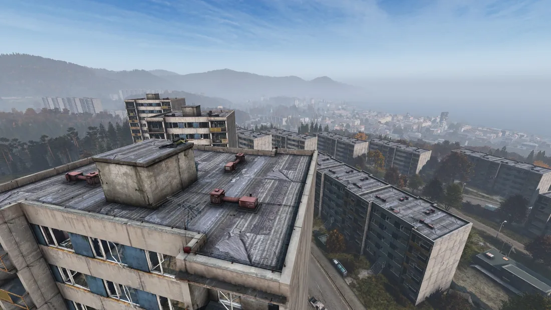
Base-game terrain: density is the part that transfers — Nasdara keeps the block-and-alley volume and swaps the architecture for mud, stone and walls.
Mechanics that sit on top of the map have their own pages: Heat & Heatstroke Survival Guide, DayZ Badlands Rebuilding System Explained and Cities, Bazaars & Loot Routes in Nasdara.
Every name there is official. Any map showing street names, base icons or loot pins before launch is guesswork over screenshots — a hypothesis, not a fact.
Confirmed Versus Unpublished
This is where pre-launch pages usually invent content. The split below is what Bohemia has released as of the Badlands pre-launch (October 2026):
| Published and citable | Still unpublished until launch on October 15, 2026 |
|---|---|
| 267 km², fully inland, west of Chernarus | Coordinates for any named region |
| The eighteen rows in the regions table | Town and city names, POI counts |
| Settlement density similar to Chernarus | Spawn points and starting areas |
| Over 5,000 rebuildable houses, ~20 variants | Loot tables, oil field and base tiers |
| Sandstorms, motorbikes, code locks, regional firearms confirmed on the October 2 feature list | Sandstorm damage and duration, heat values |
| Underground facilities on the terrain-hole system | Contaminated zone positions and gas behaviour |
Creator Program footage stays embargoed until the morning of October 15, 2026, so positions, spawn points and loot tables circulating before then are context-free screenshots or invention. Launch numbers land in DayZ Update 1.30 Patch Notes & Release Info.
FAQ
How big is the DayZ Badlands map? 267 km², fully inland — officially the largest terrain made for DayZ, about 16% more ground than Chernarus at 230 km² and about 59% more than Livonia at 168 km².
What is the biggest DayZ map? Among official terrains, Nasdara at 267 km². Larger Workshop maps already exist, but they are not official.
Where is Nasdara located? West of Chernarus, land-locked inside Takistan at its western border with Ardistan. The Dasht-e Sarman desert presses in from the east, border mountains split the west, and the southern highway leaves at the Dar-e Ardis crossing.
How many maps are in DayZ? Four official terrains after October 15, 2026: Chernarus, Livonia, Sakhal and Nasdara. Everything else is Workshop-made community content.
Are there coordinates or an interactive Nasdara map yet? No. As of the Badlands pre-launch (October 2026), no coordinates, town names, spawn points or loot tables are official. Named regions are listed on this page; positions arrive with launch data.
Related Guides
- Nasdara Map Overview: DayZ Badlands New Terrain — geography and climate behind every region above.
- Nasdara vs Chernarus: Map Comparison — what the extra 16% changes for loot routes.
- Nasdara Lore: Takistan, History & Factions — why the ruins and bases stand where they do.
- Military Bases & Bunkers: Loot Guide — the landmark type that pays off on loot runs.
More DayZ Badlands Guides
DayZ Badlands contaminated zone coordinates are not public yet. Here is how DayZ gas zones work and what Bohemia confirmed for Nasdara.
DayZ Badlands Game Pass inclusion is not confirmed, DayZ crossplay stays Xbox plus PC only, and all platforms launch October 15, 2026.
Direct sunlight drains your stats in Nasdara. Clothing, shade and hydration rules to avoid heatstroke in DayZ Badlands.
DayZ Badlands zombies are region-specific infected with a sun-bleached look and a reworked three-angle attack. Confirmed before launch on October 15.
Should you buy DayZ Badlands for $24.99? We weigh the 267 km² Nasdara map, rebuilding and bikes against the pre-launch unknowns.
Soviet-era military bases hold Nasdara's top loot, now guarded by territorial dogs. What is confirmed about DayZ Badlands military loot before launch.
DayZ Badlands motorbikes: Jana moped (about 70 km/h) and enduro (about 130 km/h) ship with update 1.30 on October 15, 2026 and ride on Experimental now.
DayZ Badlands lore: Nasdara is not an Arma 2 Takistan remake but a new 267 km² province with a confirmed history, factions and bilingual signs.